Flood in Bihar: Causes, Impacts, and Sustainable Solutions
1. Introduction
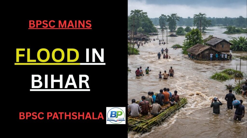
Flood in Bihar is not a one-time disaster but a recurring and structural problem that shapes the state’s economy, society, and development planning. Bihar is widely regarded as India’s most flood-prone state, with floods occurring almost every year, particularly in North Bihar. These floods cause massive loss of life, livestock, crops, and infrastructure, pushing already vulnerable communities deeper into poverty.
Historically, floods in Bihar were seen as a natural process that replenished fertile alluvial plains. However, in recent decades, the frequency, intensity, and destructiveness of floods have increased sharply due to both natural and human-made factors. Today, flood in Bihar represents a serious governance and development challenge that requires long-term, integrated solutions rather than short-term relief measures.
Complete Your BPSC Geog & Economy Preparation
If you want structured preparation of Geography & Economy for BPSC Mains, check our BPSC Geog & Economy Course with clear concepts and exam-focused notes.
| Instant access | Downloadable PDFs | Structured BPSC mains preparation |
2. Reasons for Flooding in Bihar
Flood in Bihar occurs due to a combination of natural and man-made factors, making the problem complex and persistent.
2.1 Natural Reasons
Geographical Location
Bihar lies at the foothills of the Himalayas, immediately south of Nepal. It is largely a flat alluvial plain and acts as a natural lowland for Himalayan rivers.
Himalayan Rivers and Heavy Rainfall
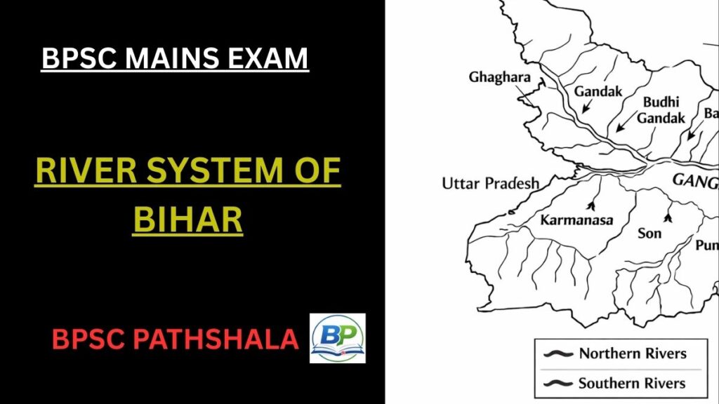
Major rivers such as the Kosi, Gandak, Budhi Gandak, Bagmati, Mahananda, Bhutahi Balan, Ghaghara, Son, Punpun, and Phalgu originate in the Himalayas or Nepal. During intense monsoon rainfall in central and eastern Nepal, enormous volumes of water flow into Bihar.
High Sediment Load
These rivers carry heavy silt and sediment. When they enter the plains of Bihar, their velocity reduces, leading to large-scale silt deposition, raising riverbeds and increasing flood risk. The Kosi River, often called the “Sorrow of Bihar”, has one of the highest sediment loads in the world and frequently changes its course.
Scale of the Problem
- About 73% of Bihar’s geographical area (around 68,800 sq km) is flood-prone
- Bihar accounts for 16.5% of India’s flood-affected area
- Nearly 22% of India’s flood-affected population lives in Bihar
- Around 76% of North Bihar’s population lives under constant flood threat
2.2 Man-Made Reasons
Embankments: Embankments were constructed extensively after the 1950s to control floods. However, they have often worsened flood intensity. Key issues with embankments:
- They narrow river channels, increasing water velocity
- Silt gets trapped inside embankments, raising riverbeds
- Rivers start flowing above the surrounding land level
- About 16% of North Bihar’s land has become permanently waterlogged (chaur areas)
- In 1954, Bihar had about 160 km of embankments and 2.5 million hectares flood-prone area
- By 2004, embankments increased to 3,465 km, but flood-prone area rose to 6.89 million hectares. This shows that embankments have not reduced floods, but increased flood vulnerability.
Farakka Barrage: The Farakka Barrage has disrupted the natural flow of the Ganga by obstructing sediment movement.
- Water level upstream rose by about 8 metres
- Around 640 million tonnes of silt accumulate annually
- This has increased flood frequency and magnitude in Bihar’s downstream areas
Encroachment on Floodplains: Unregulated construction, agriculture, and settlements on floodplains reduce the river’s natural capacity to spread floodwaters, recharge groundwater, and deposit silt safely.
Deforestation: Deforestation in the upper catchment areas of Himalayan rivers has significantly contributed to flood in Bihar. Large-scale removal of forests in Nepal and adjoining regions has increased soil erosion, causing excessive silt to be carried by rivers like the Kosi and Gandak. This silt gets deposited in Bihar’s plains, raising riverbeds and reducing water-carrying capacity. As a result, rivers overflow more frequently, intensifying floods and causing long-term waterlogging of fertile agricultural land.
Climate change: It has emerged as a major factor worsening flood in Bihar. Rising temperatures have accelerated glacial melting in the Himalayan region, increasing water flow in rivers such as the Kosi. At the same time, monsoon rainfall has become more intense and erratic, leading to sudden surges in river discharge. These extreme weather events overwhelm existing flood-control infrastructure, increasing the frequency, magnitude, and unpredictability of floods in Bihar.
3. Impacts of Flooding in Bihar
Flood in Bihar causes multi-dimensional impacts, affecting life, economy, environment, and long-term development.
3.1 Human and Economic Impacts
- Over 9,500 human lives lost since 1979 due to floods
- Thousands displaced every year
- Damage to roads, bridges, schools, hospitals, and power infrastructure
- Economic activities come to a halt during major floods
Floods force people to repeatedly rebuild homes, creating a cycle of destruction and poverty.
3.2 Impact on Agriculture and Livelihoods
- Thousands of hectares of fertile land become waterlogged
- Crops are destroyed just before harvest
- Livestock rearing suffers due to loss of grazing land
- Excessive silt reduces soil water-retention capacity
- Irrigation becomes unreliable—too much water during monsoon, too little otherwise
Agriculture, the backbone of Bihar’s economy, is therefore severely affected.
3.3 Social and Long-Term Impacts
- Forced migration and displacement
- Decline in land value in floodplains
- Psychological trauma, especially among children
- Reduced investment due to high risk perception
Flood in Bihar thus leads to long-term social vulnerability, not just immediate losses.
4. Mitigation Measures for Flood in Bihar
Flood management in Bihar requires both short-term preparedness and long-term structural reforms.
4.1 Short-Term Measures
- Improved weather forecasting and early warning systems
- Timely evacuation and disaster response planning
- Strengthening and repairing existing embankments
- Emergency shelters, relief camps, and medical support
4.2 Long-Term Measures (Elaborated)
Long-term mitigation of flood in Bihar requires moving away from short-sighted engineering solutions towards basin-level, science-based flood management. One of the most important lessons from Bihar’s experience is that embankments should be avoided on heavily silt-laden Himalayan rivers, especially the Kosi, which carries one of the highest sediment loads in the world. Continuous embanking traps silt within the channel, raises the riverbed, and ultimately increases flood risk. Instead, selective embankments combined with river widening and designated flood zones are more sustainable.
Floodplain zoning and regulation must be strictly implemented to prevent settlements, industries, and infrastructure in high-risk floodplains. This allows rivers to naturally spread excess water during peak monsoon flows, reducing destructive floods downstream. Countries like the USA have successfully reduced flood losses through such zoning laws, a model Bihar urgently needs to adopt.
At the core of long-term solutions lies river basin-level planning, rather than isolated river control projects. This includes systematic desilting of river channels, tributaries, and reservoirs to restore carrying capacity. Large dams and barrages upstream must be operated with coordinated release protocols to avoid sudden surges. Improved canal networks can help divert excess floodwater for irrigation during non-monsoon months, turning floods into a resource.
River interlinking projects such as the Kosi–Mechi Link aim to transfer surplus floodwater from flood-prone basins to deficit regions, reducing flood intensity while improving water availability elsewhere. Though complex and environmentally sensitive, such projects can be effective if implemented cautiously.
Equally important is the restoration of wetlands, oxbow lakes, and natural drainage channels, which act as natural sponges during floods. Afforestation in Himalayan and sub-Himalayan catchment areas can significantly reduce soil erosion and silt inflow. Finally, climate-resilient infrastructure planning, including raised roads, flood-proof housing, and adaptive dam and canal design, is essential as extreme rainfall events become more frequent due to climate change.
Together, these long-term measures can transform flood management in Bihar from reactive disaster response to proactive risk reduction.
5. Government Initiatives to Mitigate Flood in Bihar
The Bihar Government, in coordination with the Union Government, has undertaken several initiatives to reduce the impact of flood in Bihar, though the approach has largely remained relief- and structure-oriented. The Water Resources Department (WRD) is responsible for construction, maintenance, and strengthening of embankments along major rivers such as the Kosi, Gandak, Bagmati, and Budhi Gandak. Thousands of kilometres of embankments are regularly repaired before the monsoon season to prevent breaches.
The state has also strengthened disaster management mechanisms through the Bihar State Disaster Management Authority (BSDMA), focusing on early warning systems, flood forecasting, evacuation planning, and relief distribution. Satellite-based weather forecasting and coordination with the India Meteorological Department have improved advance alerts, reducing loss of human lives in recent years.
Relief and rehabilitation measures include compensation for loss of life, livestock, crops, and housing, along with provision of temporary shelters, food, drinking water, and medical assistance during floods. Additionally, Bihar engages in bilateral coordination with Nepal for information sharing on rainfall and river discharge, as many flood-causing rivers originate in Nepal. Despite these efforts, policy emphasis has remained skewed towards embankments, with limited progress on floodplain regulation and long-term ecological solutions.
6. Way Forward
Addressing flood in Bihar requires a paradigm shift from flood control to flood management. Complete prevention of floods is neither possible nor desirable, especially in an alluvial floodplain ecosystem like Bihar. The focus must shift towards minimizing damage while allowing rivers to function naturally.
A key requirement is the implementation of floodplain zoning and river regulation policies, which restrict construction and settlements in high-risk zones. This would restore the river’s natural space to spread excess water safely during peak flows. Integrated river basin management, including silt management and wetland restoration, is essential to reduce riverbed aggradation.
Long-term cooperation between India and Nepal is critical for sustainable flood management, involving joint river basin planning, afforestation in catchment areas, and coordinated dam and barrage operations. Climate change adaptation must be integrated into development planning, as extreme rainfall events are expected to increase in the future.
Ultimately, community participation, better governance, scientific planning, and ecosystem-based approaches are the only sustainable way forward to reduce the recurring devastation caused by floods in Bihar.
7. Conclusion
Flood in Bihar is a result of geographical vulnerability combined with policy and planning failures. While floods are a natural phenomenon, their devastating impact is largely human-made. Bihar, already economically vulnerable, cannot afford repeated losses of life, livelihood, and infrastructure. With climate change increasing extreme rainfall events, the urgency for sustainable, science-based, and cooperative flood management has never been greater. Managing floods wisely is essential not only for disaster reduction but also for Bihar’s long-term socio-economic development.
BPSC Mains Practice Questions (Based on Flood in Bihar)
- Flood in Bihar is a result of both natural factors and human interventions. Examine the causes of recurrent floods in Bihar and assess the role of embankments and river management policies.
- Discuss the socio-economic impacts of floods in Bihar. How do recurrent floods affect agriculture, livelihoods, and long-term development of the state?
- Critically evaluate the existing flood mitigation measures in Bihar. Suggest sustainable and long-term strategies to manage floods in the context of climate change.
Also Read….
- Agriculture in Bihar
- Urbanization in Bihar
- Migration from Bihar: Causes, Economic Impact, and Policy Responses
- Tourism in Bihar
Complete Your BPSC Geog & Economy Preparation
If you want structured preparation of Geography & Economy for BPSC Mains, check our BPSC Geog & Economy Course with clear concepts and exam-focused notes.
| Instant access | Downloadable PDFs | Structured BPSC mains preparation |