Physiographic Division of Bihar
1. Introduction
The Physiographic Division of Bihar reflects the natural relief features, geological structure and surface configuration of the state. Bihar is located between 24°20’10” N to 27°31’15” N latitude and 83°19’50” E to 88°17’40” E longitude. It extends about 483 km from east to west and nearly 345 km from north to south, covering a total geographical area of 94,163 square kilometres, making it the 12th largest state of India by area.
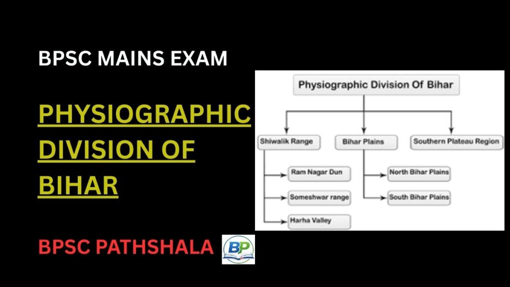
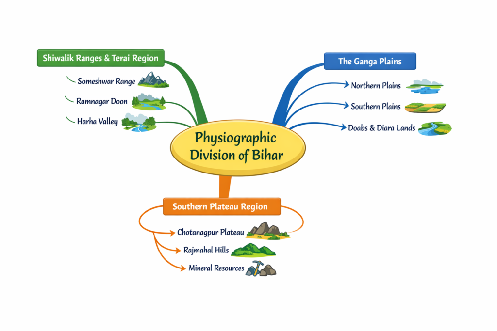
Geographically, Bihar occupies a strategic transitional position between the Himalayan region in the north and the Peninsular plateau in the south. This location plays a major role in shaping its relief features. The northern boundary is influenced by the Himalayan foothills, while the southern part connects with the Chotanagpur Plateau. On the basis of relief, geological structure and origin, the Physiographic Division of Bihar is broadly classified into three major regions:
- Shiwalik Ranges and Terai Region
- The Ganga Plains
- Southern Plateau Region
These divisions are distinct in terms of altitude, slope, soil composition and rock structure.
Complete Your BPSC Geog & Economy Preparation
If you want structured preparation of Geography & Economy for BPSC Mains, check our BPSC Geog & Economy Course with clear concepts and exam-focused notes.
| Instant access | Downloadable PDFs | Structured BPSC mains preparation |
2. Geological Background of Bihar
The Physiographic Division of Bihar is closely linked to its geological structure. Bihar presents a combination of very young alluvial formations and some of the oldest rock systems of the Indian subcontinent. Broadly, the geological structure of Bihar can be classified into three major rock systems: Tertiary rocks, Quaternary alluvium and Precambrian rocks.
Tertiary Rock System
The Tertiary rock system is found in the north-western part of Bihar, particularly in the Shiwalik region of West Champaran. These rocks were formed during the Tertiary period when the Himalayan mountains were undergoing formation. The Shiwalik hills consist mainly of sandstones, clays and conglomerates. These are relatively soft and sedimentary in nature. This region represents the youngest mountain formation processes associated with the Himalayan uplift.
Quaternary Alluvium
The largest portion of Bihar is covered by Quaternary alluvium. Nearly 90 percent of the state is made up of recent alluvial deposits brought by the Ganga and its tributaries such as Ghaghara, Gandak, Kosi, Bagmati and Mahananda. These deposits were formed during the Quaternary period and are still being renewed every year through river action. This thick alluvial cover forms the vast Ganga plains of Bihar and represents the most extensive geological formation in the state.
Precambrian Rocks
The southern part of Bihar, particularly the plateau fringe areas adjoining Jharkhand, consists of very ancient Precambrian rocks. These rocks include gneiss, granite and schist. They are among the oldest rock formations in India and form part of the Chotanagpur Plateau extension. These hard crystalline rocks are responsible for the rugged topography and presence of isolated hills in districts like Gaya, Nawada and Rohtas.
Thus, the geological background of Bihar explains the clear division between the Himalayan foothill region, the extensive alluvial plains and the southern plateau region. The Physiographic Division of Bihar is directly shaped by this geological diversity.
3. Major Physiographic Division of Bihar
(A) Shiwalik Ranges and Terai Region
The Shiwalik Ranges and Terai Region form the smallest yet significant part of the Physiographic Division of Bihar. This region is located in the north-western part of the state, mainly in West Champaran district along the India–Nepal border. It covers approximately 932 square kilometres and represents the Tertiary rock system of Bihar.
This region is an extension of the Shiwalik (Outer Himalayan) Range, which is the youngest mountain range of the Himalayas. The rocks found here mainly consist of sandstone, clay and conglomerates. Due to their relatively soft nature, these hills are prone to erosion. This physiographic region is further divided into three parts:
Someshwar Range
The Someshwar Range is the northernmost part of Bihar. It extends from the Triveni Canal in the west to Bhikhnathori in the east along the Nepal border. The maximum height of this range is about 874 metres, which is the highest point in Bihar.
Several river-cut passes are found here due to streams flowing from Nepal. Important passes include Someshwar Pass, Bhikhnathori Pass and Marawat Pass. These passes serve as important routes between Bihar and Nepal.
Ramnagar Doon
The Ramnagar Doon lies south of the Someshwar Range and covers about 214 square kilometres. It is a narrow valley region with an average elevation of around 240 metres. This area is relatively flat compared to the surrounding hills and forms the southernmost part of the Terai belt in Bihar.
Harha Valley (Doon Valley)
The Harha Valley lies between the Someshwar Range and Ramnagar Doon. It covers approximately 643 square kilometres. The Harha River flows through this valley, which gives it the name Harha Valley.
Although it lies in a hilly belt, the valley itself is comparatively plain. The region is rich in forest resources and has relatively higher rainfall compared to the plains of Bihar.
The Shiwalik Ranges and Terai Region represent the only true hilly tract in Bihar influenced directly by Himalayan geology. This region marks the northernmost boundary in the Physiographic Division of Bihar.
(B) The Ganga Plains
The Ganga Plains form the largest and most important part of the Physiographic Division of Bihar. This region extends from the foothills of Nepal in the north to the southern plateau fringe adjoining Jharkhand. It occupies nearly the entire central portion of the state and covers about half of Bihar’s total geographical area.
The Ganga Plains have been formed by the continuous deposition of alluvium brought by the Ganga River and its tributaries over millions of years. These rivers deposited sediments in the trough between the Himalayas in the north and the Peninsular Plateau in the south. The result is a vast, flat and fertile plain composed mainly of Quaternary alluvium. On the basis of location and river system, the Ganga Plains are divided into two major parts:
- Northern Plains of Bihar
- Southern Plains of Bihar
Northern Plains of Bihar
The Northern Plains extend from the Nepal border in the north to the Ganga River in the south. This region has been formed mainly by the deposition of alluvium brought by the northern tributaries of the Ganga such as Ghaghara, Gandak, Bagmati, Burhi Gandak, Kosi and Mahananda.
These plains represent the Quaternary rock system and consist mainly of new and old alluvium. The land slopes gently from north to south towards the Ganga River. The gradient of slope in this region is relatively steeper compared to the southern plains. Due to this steeper gradient and heavy rainfall in the Himalayan catchment areas, rivers carry large volumes of water and sediments, leading to frequent floods. The rivers divide the Northern Plains into several doabs (land between two rivers). The major doabs include:
- Ghaghara–Gandak Doab
- Gandak–Kosi Doab
- Kosi–Mahananda Doab
Flooding is a major characteristic of this region. Districts such as Madhubani, Supaul, Araria, Madhepura, Saharsa, Khagaria and Darbhanga are frequently affected. The northernmost part near the Nepal border is swampy in nature, while the middle part is slightly elevated.
Several important fluvial landforms are found here:
Diara
Diara lands are formed when a river divides into two channels and later rejoins, leaving a stretch of land between them. These regions are composed of new alluvium (Khadar) and are highly fertile. Example: Raghopur Diara.
Chaur (Chharan Lake)
Chaur refers to low-lying areas or seasonal lakes formed when river branches get cut off from the main channel during the dry season. These are waterlogged areas during monsoon but dry up partially in summer.
Southern Plains of Bihar
The Southern Plains extend from the southern bank of the Ganga River to the foothills of the Southern Plateau region. Compared to the Northern Plains, this region has a gentler slope, approximately 6 cm per kilometre, sloping from south to north towards the Ganga Basin.
This region is composed mainly of older alluvium (Bhangar), brought by peninsular rivers such as Son, Punpun, Phalgu, Kiul and Ajay. The soil is generally sandy and absorbs water quickly, yet groundwater availability remains adequate.
The Southern Plains are physiographically more complex than the Northern Plains. Isolated hills and rocky outcrops appear in several districts. Important hill formations include:
- Gaya Hills (about 266 metres)
- Rajgir Hills (about 466 metres)
- Kharagpur Hills (about 510 metres)
- Barabar and Giriak Hills
The western part of the Southern Plains is wider than the eastern part. Due to its gentle slope, swamps are formed near the southern bank of the Ganga between Barh (Patna district) and Bhagalpur. These swamps are locally known as Tal. An important example is Mokama Tal.
Unlike the Northern Plains, this region faces drought conditions at intervals of two to three years, leading to agricultural uncertainty.
The Southern Plains are further divided into three parts:
- Ganga–Son Doab (Kaimur, Rohtas, Buxar, Bhojpur)
- Plains of Magadh (central part)
- Plains of Ang (eastern part)
The Ganga Plains, both northern and southern, form the core of the Physiographic Division of Bihar, supporting dense population, fertile agriculture and major settlements.
(C) Southern Plateau Region
The Southern Plateau Region forms the third major component of the Physiographic Division of Bihar. This region is located along the southern boundary of the state between the Southern Plains and the Chotanagpur Plateau of Jharkhand. It extends from Kaimur in the west to Banka in the east.
This region represents the extension of the Chotanagpur Plateau into Bihar. Unlike the alluvial plains, the plateau region is composed of very ancient and hard crystalline rocks belonging to the Precambrian age. The dominant rock types include gneiss, granite and schist, which are resistant to erosion.
Relief Features
The Southern Plateau Region is characterised by rugged terrain, undulating surfaces and isolated conical hills. Important hill formations in this region include:
- Pretshila Hills
- Ramshila Hills
- Jethian Hills
- Rajmahal Hills (eastern extension)
The Rajmahal Hills are considered among the oldest geological formations in Bihar. These hills are remnants of ancient volcanic activity and are composed mainly of basaltic rocks.
Mineral Resources
The plateau region is relatively rich in mineral resources compared to the plains of Bihar. Most of the mineral deposits of the state are found in this region. Limestone, pyrite and minor mineral resources occur in districts such as Rohtas, Kaimur, Nawada and Jamui.
Sub-Divisions
The Southern Plateau Region can be divided into two parts:
Western Part
This is the extension of the Chotanagpur Plateau in Bihar. It covers districts like Kaimur, Rohtas, Aurangabad, Gaya, Nawada and parts of Jamui. The terrain is rocky and undulating with scattered hill ranges.
Eastern Part
This part is the extension of the Rajmahal Hills. It includes districts such as Bhagalpur, Munger, Banka and parts of Jamui. The region consists of old volcanic rocks and isolated hill structures.
The Southern Plateau Region differs significantly from the Ganga Plains in terms of geology, soil type and relief. While the plains are composed of fertile alluvium, the plateau region consists of hard crystalline rocks and comparatively thinner soils.
Thus, the Southern Plateau Region completes the three-fold classification under the Physiographic Division of Bihar, marking the transition from the alluvial plains to the peninsular plateau system.
4. Important Physiographic Features
The Physiographic Division of Bihar is marked not only by major regions like plains and plateaus but also by several distinct fluvial and structural landforms. These features are mainly the result of river activity, slope variation and geological structure.
Doabs
A doab refers to the land between two rivers. In the Northern Plains of Bihar, rivers flowing from Nepal divide the region into several important doabs. Major doabs include:
- Ghaghara–Gandak Doab
- Gandak–Kosi Doab
- Kosi–Mahananda Doab
These doabs are formed due to the parallel flow of rivers from north to south before they join the Ganga. The soil in these regions is generally fertile alluvium. However, due to frequent flooding and river course shifting, these areas remain highly dynamic in nature.
In Southern Bihar, an important example is the Ganga–Son Doab, covering districts such as Kaimur, Rohtas, Buxar and Bhojpur.
Diara
Diara landforms are formed when a river splits into two branches and later rejoins, leaving a stretch of land in between. These regions are usually found along the Ganga and its tributaries.
Diara areas consist of new alluvium (Khadar), making them highly fertile. Due to regular deposition of fresh silt, these lands are suitable for intensive agriculture. However, they are also prone to flooding and river erosion. A well-known example is Raghopur Diara in the Ganga basin.
Chaur (Chharan Lake)
Chaur refers to low-lying, waterlogged depressions found mainly in the Northern Plains of Bihar. These are seasonal wetlands formed due to poor drainage or when river channels get cut off during the dry season.
During the monsoon, chaurs become flooded and resemble lakes. In the dry season, water recedes partially, and some areas are used for seasonal cultivation. Chaurs are common in districts like Darbhanga, Madhubani and Saharsa.
Tal
Tal refers to swampy depressions found in the Southern Plains of Bihar near the southern bank of the Ganga. These are formed due to the gentle slope of the land (about 6 cm per kilometre), which prevents quick drainage of rainwater.
The most prominent example is Mokama Tal, located between Barh (Patna district) and Bhagalpur. Tal regions remain waterlogged during the monsoon and dry up gradually in winter. These areas influence cropping patterns and settlement distribution.
River Meanders and Natural Levees
The rivers of Bihar, especially in the alluvial plains, exhibit meandering patterns due to low gradient. Continuous lateral erosion and deposition create natural levees along riverbanks. These levees are slightly elevated ridges formed by sediment deposition during floods.
Such features are common along the Ganga, Gandak and Kosi rivers and contribute significantly to the landscape of the state.
These landforms collectively enhance the diversity within the Physiographic Division of Bihar, making the state geographically dynamic and river-dominated in character.
5. Conclusion
The Physiographic Division of Bihar clearly reflects the state’s transitional geographical position between the Himalayas and the Peninsular Plateau. From the Shiwalik hills in the north-west to the vast Ganga plains in the centre and the ancient plateau region in the south, Bihar exhibits distinct relief features shaped by geology and river systems.
The dominance of alluvial plains, combined with limited hilly and plateau areas, defines the physical landscape of the state. These physiographic divisions form the natural foundation of Bihar’s geography and explain the variation in relief across different regions.
BPSC Mains Practice Questions: Physiographic Division of Bihar
- Describe the major Physiographic Division of Bihar. Highlight the characteristics of Shiwalik Ranges, Ganga Plains and Southern Plateau Region.
- Examine the formation and features of the Ganga Plains in Bihar. Explain the difference between Northern and Southern Plains.
- Discuss the geological basis of the Physiographic Division of Bihar. How do rock systems influence relief features in the state?
Also Read….
- Agriculture in Bihar
- Urbanization in Bihar
- Migration from Bihar: Causes, Economic Impact, and Policy Responses
- Tourism in Bihar
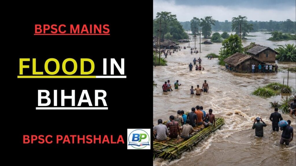
- Flood in Bihar: Causes, Impacts, and Sustainable Solutions
- Drought in Bihar: Causes, Impacts, and Sustainable Solutions
- River System of Bihar
- Inland Waterways in Bihar: Potential, Challenges, and the Way Forward
- Irrigation in Bihar: Need, Sources, Challenges, and Government Support
- Demographic Dividend in Bihar: Turning Population into Prosperity
- Economic backwardness of Bihar
- Climate of Bihar
- Soil of Bihar
Complete Your BPSC Geog & Economy Preparation
If you want structured preparation of Geography & Economy for BPSC Mains, check our BPSC Geog & Economy Course with clear concepts and exam-focused notes.
| Instant access | Downloadable PDFs | Structured BPSC mains preparation |